O V E R V I E W
Using
SOAP to access ArcGIS Server Web Services
ArcGIS Server SOAP Web services rest on two
standard XML-based W3C
specifications: WSDL (Web Service Description Language) and
SOAP.
WSDL is a specification used to describe networked XML-based services.
In general, WSDL provides a simple way for
service providers to describe the basic format of requests to their services,
regardless of the underlying protocol. One
of those protocols, and by far the most popular, is SOAP. SOAP
is used to describe the format of a message sent to a networked service
and allow computers to communicate independently of an operating system
or platform. SOAP messages can be transmitted
to a service via a number of transport protocols, including HTTP.
Consuming SOAP Services
Developer environments,
such as .NET or Java, provide SOAP toolkits to automate the process of
generating a set of local, native classes for a consumer. The
WSDL provides the client all it needs to generate the native proxy and
value objects, thus no proprietary components related to the Web service
are necessary.

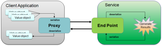
Value objects are simply objects that store values or properties. Depending
on the WSDL, there can be many different types of value objects. On
the other hand, there is only one proxy class per SOAP service type. The
proxy has both properties and methods. The methods
are designed to create and submit a SOAP request and return a SOAP response.
The proxy uses the value objects to construct
(serialize) a SOAP request. The proxy also deserializes
the SOAP response and constructs value objects to be used by the client.
So working with a rich client object environment
makes it much easier to consume and utilize a SOAP service because you
are using native objects to store properties (value objects) and manage
SOAP requests and responses (proxy) on the client.
Consuming
ArcGIS Server Web Services
A WSDL is used to generate the proxy classes and value objects for each
ArcGIS Server service type. There is one WSDL and thus one SOAP proxy
class for each service type. The capabilities of
an ArcGIS Server SOAP Web services are defined by the methods of the proxy.
The proxy is designed to work with ArcGIS
Server services in a stateless manner, thus the proxy class provides methods
to initiate stateless requests to an ArcGIS Server service and return
results. The ArcGIS Server SOAP proxy uses
value objects when calling a method and returning results. SOAP
proxies and value objects are usually generated by a SOAP
toolkit designed for a specific development environment such as .NET
and Java. For example, Visual Studio 2005
contains an integrated SOAP toolkit (wsdl.exe) for .NET developers and
the Java community maintains a number of options such as Apache Axis.
It is important to note that no ESRI components
need to be installed or available on the client. Thus
a client application can utilize ArcGIS Server Web services much like
any other SOAP-based Web service.
ArcGIS Server SOAP Web services use the following url pattern:
http://<Web
Server Hostname>/<ArcGIS
Instance>/services/<FolderName>/<ServiceName>/<ServiceType>
<Web Server
Hostname> is the hostname of the Web server on which the ArcGIS
Server Web services application is deployed.
<ArcGIS
Instance> is the name of the virtual directory in which the
Web "services" are made available. Each
instance is associated with one ArcGIS Server SOM (Server Object Manager).
<FolderName> is the name of a virtual folder on the ArcGIS
Server. One or more services may reside within
a folder. Exposing services in a folder is
optional. If
a service is not in a folder (it is exposed at the root), the FolderName
portion of the url is omitted. See the Catalog
proxy's GetFolders method to
determine if an ArcGIS Server site has folders.
<ServiceName>
is the name of the ArcGIS Server service.
<ServiceType>
is the service or service extension type. This
type must provide a WSDL to be utilized via SOAP. Valid
service types are listed in the table below.
The WSDL for a service or extension will provide
the necessary information to determine how to interact, via SOAP, with
the Web service. The WSDL can be returned by adding
"?wsdl" to the url.
ArcGIS Server Web Service proxies and value objects
The proxy and value objects for an ArcGIS Server service only need to be
generated once per service type. Once the Web service
proxy and value objects for an ArcGIS Server service have been created,
they can be reused with other ArcGIS Server Web services of the same type,
even though the proxy class name contains the original service name (dynamic
proxies only). For example, if a Web service
proxy class is generated dynamically using a map service named "NorthAmerica",
the proxy class name will be "NorthAmerica_MapServer". The
default endpoint for the MapServer proxy will be associated with the NorthAmerica
map service. To use another ArcGIS Server Web map
service named "Europe", set the Url property to define the Web
service endpoint to the "Europe" ArcGIS Server Web map service.
The same applies for all ArcGIS Server service
types. A comprehensive list of service types and
descriptions is provided below.
|
Service
|
Service type |
Description |
|
Catalog |
not applicable |
Use to access to service lists and properties
on a ArcGIS Server Web site. |
|
Map |
MapServer |
Use to generate and retrieve map content or
query attributes and features. |
|
Feature |
FeatureServer |
Use to query and edit features. |
|
Geocode |
GeocodeServer |
Use to assign locations to address attribute
information. |
|
GeoData |
GeoDataServer |
Use to create local copies of remote data,
execute geodatabase queries, and synchronize edits with other geodatabases.
Designed to work with geodatabases directly. |
|
Geometry |
GeometryServer |
Provides a set of useful and common operations
(buffer, projection, etc.) on arrays of geometries. |
|
Geoprocessing |
GPServer |
Use to interact with GIS operations for data
analysis, data management, and data conversion. |
|
Globe |
GlobeServer |
Use to access to ArcGIS Globe layers for query
and display in a 3D environment. It is designed
for ArcGIS desktop applications only. |
|
Image |
ImageServer |
Use to generate map content from raster data. |
|
Network Analysis |
NAServer |
Use to generate network solutions, such as
routing, service area generation, determining closest facilities, and
calculating Origin-Destination cost matrices. |
|
Mobile |
MobileServer |
Use to provide map and data access to applications
developed using the Mobile SDK. It is designed
for Mobile SDK clients
only. |