Property name
Type
Description
MinimumCandidateScore
integer
When a geocode
service searches for likely candidates in the reference data, it uses
this threshold to filter the results presented. Locations that yield a
score lower than this threshold are not presented.
The minimum candidate score for a locator is
a value between 0 and 100. By default, this is set to 30. If a geocode
service is unable to find any likely candidates for an address that you
want to geocode, you can lower this setting so candidates with lower scores
are presented.
SideOffsetUnits
Unit
The reference unit in which to specify the side offset (SideOffset property).
SpellingSensitivity
integer
Spelling sensitivity determines how much variation a geocode service will allow when it searches for likely candidates in the reference data. A low value for spelling sensitivity will allow "Mane", "Maine", and "Man" to be treated as match candidates for ”r;Main”. A higher value will restrict candidates to exact matches. The spelling sensitivity does not affect the match score of each candidate; it only controls how many candidates the service considers. The geocode service computes the match score of each candidate and ranks the candidates by score.
The spelling sensitivity setting for an address
locator is a value between 0 and 100. By default, the spelling sensitivity
is 80, which allows for only minor variations in spelling. If you are
sure your addresses are spelled correctly, you can set a higher spelling
sensitivity. If you think your addresses may contain spelling errors,
you should use a lower setting. The geocoding process takes longer when
you use a lower setting because the service has to process and compute
scores for more candidates.
MinimumMatchScore
integer
The minimum match score setting controls how closely addresses have to match their most likely candidate in the reference data to be considered a match for the address. A perfect match yields a score of 100. A match score between 80 and 99 can generally be considered a good match. An address below the minimum match score is considered to have no match.
The minimum match score for a locator is a value between 0 and 100. By default, this setting is 60. If your application demands that addresses be located with a high level of confidence, you should set a higher minimum match score. If you want to maximize the number of addresses that can be matched and don't mind if some addresses are potentially matched incorrectly, you can use a lower setting.
When batch geocoding
(see the GeocodeAddresses
method), the minimum match score must be met or exceeded to be considered
a match. If more than one match is found, the candidate with the highest
match score is assigned.
EndOffset
integer
Geocode services that use reference data with line geometry, such as those based on the US Streets styles, can interpolate a position along reference features for a geocoded address. To prevent features that are located at the end of a reference feature from falling on top of other features (for example, a cross street), the locator can apply a squeeze factor, or end offset, to the location of a geocoded address. The end offset setting of a locator is expressed as a percentage of the length of the reference feature, between 0 and 50 percent. An end offset setting of 0 percent will not offset features from the end of the reference feature. An end offset of 50 percent will locate all features at the middle of the reference feature. By default, the end offset setting for an address locator is 3 percent.
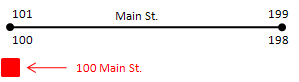
In the illustration below, the address, 100
Main St. has been offset from the street feature by the side offset distance
of 25 feet. This address falls at the end of the street feature and is,
therefore, in line with the end of the street feature.
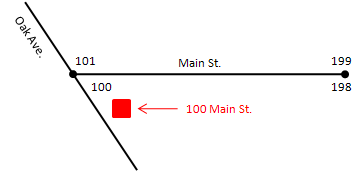
When streets intersect at odd angles, specifying
an offset distance can have the undesirable effect of placing the address
so it appears that the address does not belong to Main St. but rather
to Oak Ave. This is shown in the illustration below.

An end offset can be used to adjust the location
of the address toward the center of the street feature. Using an end offset
will often rectify the condition shown in the previous diagram. In this
example, a squeeze factor of 10 percent was used to move the address toward
the center of the street feature by a distance equal to 10 percent of
the length of the feature.
IntersectionConnectors
string
Geocode services that are based on US Streets locator styles can geocode street intersections in addition to street addresses. Intersections are designated as two streets delimited by an intersection connector string. Some examples of intersection address are "Hollywood Blvd. & Vine St." and "Yonge St. | Bloor St."
The intersection connectors setting lets you specify all the strings that the geocode service will recognize as intersection connectors. By default, the symbols &, |, and @ are recognized as intersection connectors. You can add additional symbols or words to indicate intersection connectors.
Symbols or words listed as intersection connectors will be used exclusively for intersection addresses. For example, "123 A and B St" will always be considered as an intersection address if "AND" is added as an intersection connector.
MatchIfScoresTie
boolean
If a geocode service
finds two or more reference features that have the same highest match
score, you can specify whether to match an address arbitrarily to one
of these features.
Use this setting to specify whether to arbitrarily match these addresses
(true) or leave them unmatched (false). In either case, you can review
addresses with tied candidates scores using the FindAddressCandidates
method.
OutputSpatialReference *
SpatialReference
Every geocode service uses the spatial reference
of its reference data and returns match locations in this spatial reference.
You can use this property to define the spatial
reference of (reproject) the geocoded point returned from an address match
operation.
SideOffset
integer
Geocode services can use reference data containing
address range information for each side of the street, such as US Street
address styles. Locators based on these styles
can determine which side of the street an address is located.
For cartographic purposes, you can specify a side offset for geocoded features
when using these styles of locators. When you specify a side offset, the
geocode service locates geocoded features at the specified distance, based
on map units, from the street centerline on the correct side of the street.
SuggestedBatchSize
integer
The number of addresses to locate during a single request to a geocode service using the GeocodeAddresses method. This is merely a performance recommendation, not a hard limit. The default maximum batch size is 500.
WriteXYCoordFields
boolean
Use this setting to create attributes in geocode results that contain the x,y coordinates of the geocoded features. When true, the geocode service will create two attribute fields in the results, one for the x-coordinate and one for the y-coordinate. These attributes are not valid for an address if the address is not matched.
WriteStandardizedAddressField
boolean
Applies only to Pre_ArcGIS 10 locators only - This setting allows you to create an attribute in geocode results which contains the standardized address. The contents of this field for each address are the address components used by the geocode service, separated by the pipe (|) character. This attribute is useful for displaying how the service standardized the addresses.
WriteReferenceIDField
boolean
Use this setting to create an attribute in a geocode results which contains the ID of the reference feature to which an address was matched. This attribute is not valid for an address if the address is not matched.
WritePercentAlongField
boolean
Geocode services that are based on US Streets locator styles can interpolate a position along the reference feature for a geocoded address. Use this setting to create an attribute in a geocode results which contains the position along the reference feature to which the address was matched. The value of this attribute is a number between 0 and 100, with 0 indicating the starting node of the reference feature and 100 indicating the ending node of the reference feature. This attribute is not valid for an address if the address is not matched.